The Hiking High Falls Conservation Area offers a lot, including some great hiking trails and two beautiful waterfalls. The 47-acre High Falls Conservation area near Philmont, New York, features a system of Red, Blue, and Green trails.
You can watch the main waterfall in its entirety from the High Falls overlook, which can be reached straight from the Green Trail. There are seats for relaxing or admiring the trees along the routes. Several bird species may also be seen, including the Pileated Woodpecker, and many others, depending on the time of year you visit the Hiking High Falls Conservation Area.
The park is also home to wildlife such as eagles, bears, and deer. You can also enjoy a swim in the lake below the waterfall, which is another excellent feature of visiting the High Falls Conservation Area.
Hiking Options
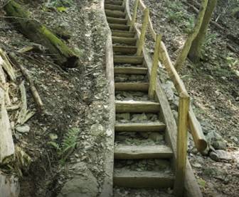
The High Falls Conservation Area has a total of 1.5 km of moderate to easy hiking paths. The trails offer an excellent opportunity to get outside and take in some breathtaking views, even if they are neither lengthy nor challenging. In order to explore some of the park’s greatest features, you can also go off-trail trekking for a short distance.
The green-blazed route departs into the woods from the parking area. It soon passes a bench and crosses a bridge before turning right. Stay on the green route as the red- and blue-blazed trails shortly diverge to the left and right.
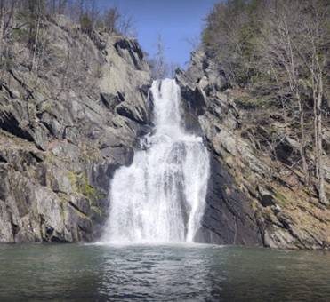
The solely authorized viewing area for High Falls is at the end of the red-blazed route. The 150-foot waterfall may be seen cascading down the rocks from here. While this is a beautiful view year-round, the summer months can be a bit overgrown, so if you can, try to visit in the spring or the fall.
There used to be a dozen mills along the banks of Agawamuck Creek and close to the waterfall. The dam at the top of the falls is still discernible from this viewing spot, despite the fact that most of them have little visible remains now. Once you reach the blue-blazed route that branches off to the right and descends to the stream, continue on the green-blazed trail that is downward. As you descend to Agawamuck Creek, stick to the blue-blazed track.
Continue straight down and upstream for an additional tenth of a mile if you choose to continue. The end of the route offers a second-best view of High Falls, but there is no trail, and you will need to clamber up and over the stones that border the creekbed, which can be a bit tricky. If you decide to attempt this part of the trek, keep in mind that it might be dangerous, especially if the rocks are wet and slick. You’ll reach the foot of High Falls after a short while of scrambling. A sizable pool of water separates you from the waterfall, which is located on the other bank.
Take advantage of this 2.4-km circle route close to Hudson, New York. It usually takes 38 minutes to finish and is regarded as simple. Since birding, hiking, and strolling are all highly popular activities here, you can run into other people while exploring. The walk is most enjoyable from April through December. This route is fairly easy to navigate because of neither steep steps nor grades.
The far-off waterfall is attractively framed at the endpoint for the sitting area in the naturistic stadium design. The trails are well-kept and simple to navigate. The entire distance to the waterfall is shaded, which is another added advantage if you plan on visiting during the afternoon. There are many side trails to enjoy the river. You can also bring your swimming gear if you plan on going on a swim. Here there’s a sitting area with a fantastic view of the falls.
To learn more about the location, you’re going to visit, make your way from the parking lot to the clearly indicated kiosk beyond the gate. Sign in as well, so they are aware of how many people this fantastic location is attracting.
A sign that points in both directions and reads “To Falls” is used to identify the Green/Red intersection. Take a right to join the Red Trail and begin the day’s largest (but still not particularly steep) ascent over the next. You’ll ascend 112 feet over 4 km. You will come back to this intersection after seeing the falls overlook because this is the start of a loop.
The Lower Blue Trail branches off to the right immediately before you return to the wooden footbridge, a quarter-mile from the Upper Blue Trail. The Lower Blue Trail descends to the water’s edge once more, but this time the vista is of rubbish that people on the other side of the stream tossed down the hill instead of magnificent waterfalls.
Getting There
Go north on Poughkeepsie, taking the Taconic Parkway. The Taconic exit on Route 44 is 36 miles north of your exit, NY 217, toward Philmont. Take a left onto Rt. 217 West after leaving the exit for Philmont/NY 217. Take another left onto Roxbury Road approximately 2.6 miles after passing through the community of Philmont and shortly before leaving town on the opposite side. You will find the large, clearly signposted parking lot to your left.
Rates and Timings
The great news for those planning a trip to the Hiking High Falls Conservation Area is that there’s no access fee, which means you can just walk in. The timings of the High Falls Conservation Area are from 7 am to 8 pm, seven days a week.